Raufarhofn 66:27.4N 15:56.6W
Millybrown
Mark Hillmann
Tue 24 Jun 2008 13:27
|
Tied up in Raufarhofn after sail of over
24 hours. This is the most northerly port of mainland Iceland, 6 miles south of the arctic circle, according
to my book. That makes the arctic circle 66:33, or at the north
end of the runway on the little island of Grimsey, north of all mainland
Iceland.
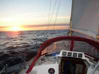
But what is the arctic circle? These three
pictures were taken at 66:22.8'N over the period when sunset should have
happened. The sun was half a diameter above the horizon. Was
refraction making it appear that it had not set?
   12 midnight (Iceland
time)
0030
0100
I looked up the tables this morning and sure enough
at an apparent altitude of 20' the refraction correction is 30' which would
push the sun back up again.
My gps is also confused as it gives sunrise as 0010
UTC and sunset as 0202 UTC. This would mean the sun is down all
day Iceland is on UTC (ie GMT) rather than UK summer
time..
Yesterday was warmer, until we rounded
Langaness at 10pm I had only a jacket on outside, rather than full
waterproofs. As we were coming from a run on to a beat and I
still have not found out what the tides do round headlands here, a wet beat in
broken water was anticipated. It was not too bumpy and the rest of
the night was a long but peaceful beat across to Raufarhofn. Sleeping 45
mins at a time, as there was nothing around.
This morning was cold, so the heater went on.
I remembered that my phone has a thermometer, it was reading 21C in the
cabin. Outside it started at 3 C out at sea and has now got
right up to 23 C in the sun in
harbour. The water temperature is showing as 10C.
|